Nestled in the Sierra Foothills near Auburn, California, Hidden Falls Regional park is one of the nicest examples of lowland foothill country you’ll find around. With its expansive trails, mixture of chaparral, oak, and pine woodland, Hidden Falls is a popular place with hikers, mountain bikers and anyone who enjoys a little peace and quiet.
As of this weekend, Hidden Falls has expanded nearly five-fold, from 200 acres to about 1200, with miles and miles of new trail. I’ll go out there shortly, to explore it all. (Astute readers may recall that this was the park I’ve done a couple of volunteer stints in over the past few months, building trail and installing signs.) This hike, which lies entirely within the original boundaries of the park, loops back and forth, covering about six miles and most of the trails within the area. You can shorten the hike at a number of points, creating a hike perfect for your abilities and time.

Entrance “sign” for Hidden Falls

Looking out over the parking area and main trailhead. Concrete path in center is wheelchair-accessible.
Starting from the parking lot, where you’ll find restrooms and water, walk past the display board and onto the fire road (South Legacy Way), turning right almost immediately and down onto the Poppy Trail. The trail will start descending, switchbacking into the canyon below through a mixture of pines, oaks and open spaces, and arriving after about a mile at Deadman Creek. A couple of points here will allow you to go right down to the water, but be sure to watch our for poison oak.
Continuing along the creek, the trail will intersect with South Legacy Way at a bridge over the creek. You’ll actually see two watercourses: Deadman Creek, and the Whisky Diggins canal, a water diversion constructed back in the goldmine era to provide water for the gold digging operations. If you follow the use trail upstream for a few dozen yards, you’ll find the diversion point, a small concrete dam.
Crossing the bridge, turn right onto the trail marked Blue Oak Loop. Follow this trail uphill through oak woodland, reaching a four-way intersection with the Turkey Ridge Trail, Seven Pools Vista Trail, and the fire-road topping the ridge. Cross over the fire road, picking up the Seven Pools Vista Trail on the other side. After about .4 miles of walking, you’ll arrive at a rocky viewpoint overlooking the Coon Creek Gorge. It’s a good place to have a bite to eat and watch the turkey vultures circling the canyon on the thermals overhead.

Small bridge on the Blue Oak Loop Trail

Ascending the Blue Oak Loop Trail

Looking down into Coon Creek Gorge

Turkey vulture on the thermals
Continuing on the Seven Pools Vista Trail, descend through some shade growth to the intersection with the Seven Pools Loop trail. Turn left and follow this trail .2 miles to the Pond Turtle Trail. At the junction, a short side trip to the right will take you to the creek and the Seven Pools. Continuing straight, across the Pond Turtle Trail, look for the junction on your left to the Quail Run Trail. The Quail Run Trail will bring you back up out of the canyon to the top of the ridge and the wide firebreak.
As you near the top of the ridge, turn right on to the Blue Oak Loop trail, crossing through the wide fire break at the top of the ridge (North Legacy Way). This firebreak is known as a “shaded fire break”, where all of the ground fuels (grasses, brush, etc.) have been removed, but the larger trees are left in place. The removal of these ladder fuels prevents the fire from spreading into the trees, so it acts as an effective firebreak despite the trees being there to provide shade on hot days.

Shaded fire break on North Legacy Way; note the lack of underbrush
The Blue Oak Loop Trail now descends back down to the Deadman Creek Gorge. Look for the Hidden Falls Access Trail on your right, and follow it downstream for about half a mile. Look for the short staircase on your left, and follow that trail down to the Hidden Falls overlook, where you’ll find a large wood platform built over the side of the canyon and overlooking Hidden Falls itself.

Platform overlooking Hidden Falls

Hidden Falls
Returning along the Hidden Falls Access Trail, you’ll find yourself back at the Whiskey Diggins Bridge. Cross the Bridge and turn right onto the fire road, South Legacy Way. The hike up South Legacy Way will take you all the way back up to your starting point at the parking lot.

Looking up the gorge to the new bridge, which leads to the newly opened parts of the park
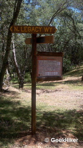
One of my favorite things about Hidden Falls: all (or nearly all) of the major trail junctions have both trail names and trail maps of the entire park showing where you are. Wonderful stuff!
| Total Distance: 5.7 miles
Elevation Gain/Loss: ~250’/250′ Hike Profile: Website: http://www.placer.ca.gov/departments/facility/parks/hiddenfalls Directions: From Sacramento, drive east on Interstate 80 approximately 33 miles to Auburn, California. Take the exit for CA State Highway 49 (to Grass Valley), and turn left. Drive 2.7 miles north on Highway 49, then turn left onto Atwood Road. Drive west on Atwood Road, which will merge into and become Mt Vernon Road. 3.3 miles from Highway 49, turn left to stay on Mt. Vernon Road. After another mile, turn right onto Mears Drive. One half mile later, turn right onto Mears Place and follow it .2 miles to the park entrance. Address is 7587 Mears Place, Auburn, CA Fee: none (as of this writing) Trail map from the Regional Park website, shaded to show new area. Original high-rez map can be downloaded here.
|


Wow, looks gorgeous!
By: tgaw on May 29, 2013
at 7:33 am
It is! And most of those pictures are from winter… you should see it in the spring!
By: GeekHiker on June 4, 2013
at 10:01 pm
Looks like a wonderful place to unwind. Have to admit I miss hiking that involve creeks and waterfalls. Not many here in eastern Nebraska. Most of our water is in the form of ponds and swamp which do have their own charm.
By: Bruce H. on June 3, 2013
at 4:26 pm
Well, given how little precipitation we’ve gotten this year, there may not be much of them by the end of summer. You’ll have to do a post about the charms of a swamp to convince me of that one, though. 🙂
By: GeekHiker on June 4, 2013
at 10:03 pm
Between you and Bruce, I’m seriously thinking about hiking. Plus, new shoes, right? This place looks lovely, and the views are just stunning!
By: Miss McCracken on June 8, 2013
at 11:21 am
I just came back from this place today and you are absolutely right! It’s stunning! Thank you for sharing your experience!
By: Sonia on April 19, 2014
at 6:04 pm
[…] Hidden Falls- Off Hwy 49 […]
By: IAY Hiking Guide | It's All Yoga on May 27, 2014
at 6:19 pm