Last Friday a storm rolled through Los Angeles, clearing a lot of the dust and particulate matter out of the air, leaving clear blue skies this morning. With bright sun streaming in my windows at temperatures in the sixties, I headed for the Angeles and San Gabriel Peak.
Of course when I reached the trailhead at 4,740 feet, things were a bit chillier. Hopping out of the truck, the thermostat read a nippy 46 degrees. Of course, I wore shorts. Duh. The first part of this hike was done, shall we say, at a brisk pace.

Morning frost on a pine cone
San Gabriel Peak is a good shoulder season hike: the summers are usually too hot, and the road is often closed by snow or ice in the winter.
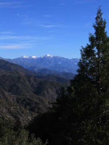
The storm dropped the first snow of the season on Mt. Baldy
For years one of the main ways to reach San Gabriel Peak was via the road to Mt. Disappointment. Mt. Disappointment was so named because the surveyors in 1875, battling their way through the scrub and brush to reach San Gabriel Peak, reached this point first… 100 feet lower.
Now Mt. Disappointment, while still affording a good view down Tujunga Canyon, is marred by it’s flattened top, having been blasted away to make room for a Nike missile site in the 60’s and now home to an array of radio towers. Luckily, San Gabriel Peak has similar views without the scarring.
Originally, the only way up the trail was via the road, until 1988 when the JPL Hiking Club built a newer, shorter, steeper trail up to the top. We’ll use that trail for the return part of the trip.
And, seriously, rocket scientists who build trails, how cool is that?
Looking east from the road towards the San Gabriel watershed & Mt. Baldy
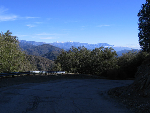
Heading up the road past the locked gate, you’ll be rewarded with vistas to the east of the East Fork San Gabriel Canyon, looking all the way out towards the high peak of Mt. Baldy. To the west your view will look down the Tujunga Canyon, and to the north Strawberry Peak dominates the landscape.

Jointed granite along the road cut
Looking down from here, you can see the road you drove in on: the twisting curves of Highway 2 as it threads its way up the mountain.

Looking down on Highway 2
The San Gabriel’s are notorious for extremely heavy rainfalls, and debris dams protect the infrastructure below.

Debris dam along the road at the head of Cloudburst Canyon
Here and there along the road, relics of the Nike era show up.

Old sign along the road
I wonder what would happen if I called the operator and asked for “Los Angeles, Tucker 2221. Collect, please.” Heh.
There’s no real route finding here, of course, just follow the road as it winds around, giving you occasional views of the peaks ahead of you.

Your destination: Mt. Disappointment on the right, San Gabriel Peak on the left
At about 2.8 miles you’ll reach the saddle between the two peaks. Make a sharp u-turn here to follow the road up to Mt. Disappointment, walking between chain-linked radio towers and buildings to the rocky outcrop at the end of the road.

View of San Gabriel Peak from Mt. Disappointment
Once you’ve had your fill of the views from here, return to the saddle and head straight, under some pine trees and past some giant concrete slabs, and pick up the narrow trail at the end of the road.
The trail will dip slightly, then ascend a series of switchbacks on soft granite up to the top of the peak itself. A metal bench is placed across two old fire tower supports for you to relax and drink in the views. The graffiti on the bench reflects the “rocket scientist” hikers on this trail. Spray panted on the bench: “It’s only twenty miles up to space.”
If the view is clear (it was today but didn’t photograph well) you can clearly see downtown LA, the broad curve of Santa Monica Bay, the Palos Verdes Peninsula and out to Catalina Island.
To the north and west stretch the San Gabriel Range, with the telescopes of Mt. Wilson further down the ridge and the peaks of Baldy and the mountains above Big Bear beyond.

Panoramic of the San Gabriels. The Mt. Wilson Observatory is at the right
When you’ve had your fill of the views, return down the trail to the road, looking for the signed JPL trail on the right. The trial switchbacks steeply down the side of the mountain through forests of oak and Manzanita.

The trail heading down under leafless winter oaks
Near the bottom, you’ll catch view of your car in the parking lot below. Be careful on the last few hundred feet of trail. Although it had been recently maintained while I was there today, this section is made of loose granite and the footing can sometimes be tricky.
Total Distance: 6.0 miles
Elevation Gain/Loss: 1,620′/1,620′
Website: http://www.fs.fed.us/r5/angeles/
Directions: From Interstate 210, exit Highway 2 North in La Canada Flintridge. Follow the highway to the Red Box parking area and turn right on to Mt. Wilson Road. Drive .4 miles up the road and turn right onto the Mt. Disappointment service road (it’s a little hard to see from the road). Park in the dirt lot (there’s room for about four cars), being careful not to block the gate. National Forest Pass required.


You mean you didn’t call???
Love the shot of San Gabriel from Mt. Disappointment. I thought there was a randomly decorated xmas tree there for a moment.
By: just a girl on December 3, 2007
at 10:05 pm
Like JAG, I also have a remark about that photo. What type of tree is that in the foreground of the photo captioned “View of San Gabriel Peak from Mt. Disappointment”? I’ve never seen a tree like that our east here.
By: charlotte harris on December 4, 2007
at 5:47 am
Does some have the job of going around and cleaning out the debris dams? They would probably get clogged. I’m just wondering who gets the chance to say they do that for a living.
By: lea on December 4, 2007
at 6:26 am
Looks like a great hike. Great photos. I know a few rocket scientists (not JPLers though) and they are all cool people.
I bet if you called the number you would hear some mechanical voice asking: “Do you want to play a game?”
By: Homer-Dog on December 4, 2007
at 7:05 am
just a girl – I was tempted.
charlotte – Not a tree, just the stalk of a yucca. In the spring it’s covered in flowers, but here in the winter, the flowers are all gone.
lea – actually yes. Costs ’em a fortune, too.
Homer-Dog – It was, just a bit chilly. Nice to meet someone else who can’t resist a good 80’s reference.
By: geekhiker on December 4, 2007
at 10:42 pm
Great re-cap!
I haven’t heard anyone mention a NIKE missile site since I was in Washington a couple years ago and was told the playground I was standing on actually used to be one!
By: Aaron on December 6, 2007
at 10:10 am
Nice pictures and writeup, but that wasn’t the first snow on Baldy, it’s snowed on at least two separate occasions in September and October.
By: Someguy on December 11, 2007
at 9:17 pm
Aaron – Thanks. You’d be surprised how common they were on the west coast.
Someguy – LOL, well, I stand corrected then! 🙂
By: geekhiker on December 11, 2007
at 9:24 pm
[…] San Gabriel Peak on (single)geekhiker.wordpress.com […]
By: Mount Disappointment Trail to San Gabriel Peak | Los Angeles | Hikespeak.com on January 19, 2011
at 8:28 pm
[…] San Gabriel Peak on geekhiker.com […]
By: San Gabriel Peak via Mount Lowe Road | Los Angeles | Hikespeak.com on April 27, 2014
at 8:34 pm