I swear, I think I’m cursed to be cold on this hike.
I’ve only done it once before, on a mid-summer day that, for whatever reason, was cloudy and cold. A couple of weeks ago I did it on a spring day that was forecast to be mostly sunny; instead, it was cloudy, cold, and slightly rainy.
Don’t misunderstand me, here: it’s a great hike. And someday, I’m going to do it when the sun is shining.
The Bridge to Nowhere hike can be a something of an adventure, especially with the healthy rainfall that we’ve had this year. It follows, roughly, the course of an old highway that road builders attempted to build back in the 1930’s to Wrightwood. (More info here.) A second attempt along the west wall of the canyon was also abandoned.
The road is gone now, having been washed out long ago by floods and rockslides and leaving the bridge they built spanning the narrow canyon of the river stranded four miles upstream. Seventy years after it was abandoned, the bridge is in remarkably good shape and is one of the most popular hikes in the San Gabriels.
The trail heads up the East Fork of the San Gabriel River, occasionally walking along old roadbed and requiring several river crossings along the way. In the summer and fall, when the river’s flow has dropped to a trickle this is pretty easy (usually ankle or knee depth); after fresh rains the fordings were waist high and the current packed a goodly force. During the winter and immediately after a storm the journey would be downright dangerous if the water level is high and shouldn’t be attempted.
From the trailhead, fill out the wilderness permit (you’ll be hiking in the Sheep Mountain Wilderness) and then start up the canyon, quickly descending from the parking area to the river and passing a small campground located on a bench above the river a half mile in.

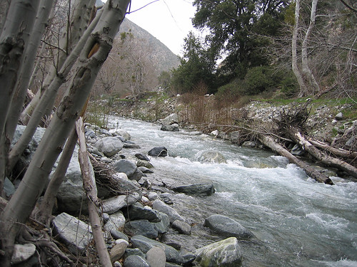
The start of the hike from the East Fork trailhead
For the next two miles, the trail swings back and forth across the river, occasionally touching parts of the old road bed and working its way past concrete bridge supports. Most of the crossings are relatively easy, depending on how much water is flowing downstream at the time.
Rushing flow of the East Fork

Tributary entering the East Fork between old concrete bridge supports
After about two more miles be sure to look across to the west wall of the canyon for a view of Swan Rock, a light shape embedded in darker rock that’s best seen under flat lighting conditions. It’s a good marker to let you know you’re about halfway to your goal.

Swan Rock along the trail
A mile beyond Swan Rock, the trail will swing up to the right and climb onto the old roadbed. Continuing along the gentle incline of the old roadbed, you’ll slowly gain altitude, picking your way every so often past sections that have slid away. As you near the bridge the road enters private land, a grandfathered inholding in the forest. You’re allowed to pass through to the bridge, but be sure to stay on the trail.

Narrow trail climbing away from the river

Old roadbed nearing the bridge
Finally you’ll arrive at the bridge itself just where the canyon starts to narrow. The area is usually pretty crowded owing to the bungee jumping operation set up there. (Bungee jumping is not my thing, but if it’s yours, contact Bungee America.) The noise of the river and surrounding wildlife is drowned out by the calls of “1-2-3-Bungee!” every few minutes.

The Bridge to Nowhere

Bungee Jumper at the bridge

Looking into the narrows of the East Fork from the bridge
(That said, I hope someday I can do this hike on a weekday when they’re not jumping. The quiet, abandoned bridge spanning the canyon must be a nice sight.)
When you’ve had your fill of the views, return the way you came back downstream.

Along the return path heading downstream
Total Distance: 9.6 miles
Elevation Gain/Loss: 1,000′/1,000′
Website: http://www.fs.fed.us/r5/angeles/
Directions: From Interstate 210, exit Highway 39 North (Azusa Ave.) in Azusa. Drive north 11.7 miles to the junction with East Fork Road and turn right, crossing the river. Follow East Fork Road to the end, just past the turn off for Glendora Mountain Road (approx 7.1 miles). A good sized parking lot is available but often filled, so you can park along the road where allowed. National Forest Pass required.


I’ve no interest in the bungee either. The idea of stretching all my joints out and snapping them back together holds no appeal.
Looks like a pretty hike.
By: just a girl on March 11, 2008
at 10:50 pm
Great hike. It’s always find it interesting to find abandoned remains on the trail. The bungee thing would have irritated me though.
By: Homer-Dog on March 12, 2008
at 6:16 am
Wow!
*THAT* bridge was built back in the 30’s??
As per the usual, a wonderful writeup. Thanks for sharing. (Where are all the trees?) 🙂
By: Aaron on March 12, 2008
at 11:00 am
just a girl – yeah. Yet parachuting is something I might try someday. It is; I’m supposed do it this summer & I’m hoping for sun!
Homer-Dog – It’s one of those “classic” hikes every LA hiker should do.
Aaron – It’s in amazingly good shape, isn’t it? (Lower elevation, southern exposure = chaparral.)
By: geekhiker on March 12, 2008
at 8:21 pm
As usual, great pics … Love the bridge!
By: dobegil on March 12, 2008
at 9:27 pm
I hiked to the bridge in the 60’S with my dad.There was a tunnel, then, just past the bridge. It made it a lot easier to hike further in.My dad lived and prospected for gold a few miles past the bridge in the years after WW2. Back then you never saw another soul in the canyon. This fall We plan to spread his ashes at the site of one of his favorite places.
By: michaele on July 25, 2008
at 1:47 pm
I hope you got a chance to put your father where he wanted to be for eternity. At least his mortal remains. He is looking down on you with a smile from heaven for carrying out his wishes. God bless..
Tucker… Think I will make that hike for the first time this summer , 2013! Take care
By: Eric tuck on April 14, 2013
at 9:03 pm
[…] […]
By: Fire in Hills above Azusa - The RadioReference.com Forums on August 26, 2009
at 2:54 pm
my dad took me there on my first backpack….it was 1978 will never forget it. hes gone now and its only memories like this…..
By: matt on September 19, 2010
at 12:46 am
[…] More information: Trip reports here, here and here. […]
By: The Bridge to Nowhere « Nobody Hikes in L.A. on September 23, 2010
at 6:45 am
hi! thanks for the post. i’m planning this hike this saturday (4/24) and i had a few qs:
1. i read that there are several river/stream crossings. do i need to wear swimming trunks and sandals for the hike? (only asking cuz there’s been a lot of rain lately in socal)
2. how long does the hike take? i’ve seen reports where they say it’s a 4-5hr hike to a full day hike.
thanks!
By: Daniel on April 19, 2011
at 3:00 pm
Daniel – 1) That’s what most people do, or at least a pair of shoes you don’t mind getting soaked. I don’t know how high the water is right now, so you might want to call the ANF Ranger Station to check. 2) I’d say 4 or 5 is a good estimate. Time depends on a lot of things, like how long the fordings take or, if you’re like me, how often you stop to take pictures. Hope you have a good hike!
By: geekhiker on April 19, 2011
at 6:59 pm
Anybody been on this hike lately to know how deep the river/stream crossings are this time of year? Is the entire trail easily spotted to follow?
By: Tisha Suarez on October 2, 2012
at 10:53 am