(Did this hike two weeks ago, the day before the Malibu Fires. While the fires were burning, I held off posting since, well, to be frank, I didn’t want to jinx things since the fires were burning east towards Topanga State Park.
Luckily the fire didn’t burn that far east, so here’s the hike.)
The Eagle Rock loop was one of the first hikes I ever did when I first moved to the LA area. It’s a good introduction to the mixed chaparral and oak woodlands that cover the Santa Monica Mountains, and is only about a twenty minute drive outside of Santa Monica.

Oak tree & grassland in Topanga State Park
The trail is mostly fire roads, which is both good and bad. Good since you aren’t pushing your way through overgrown chaparral on narrow single-track trails. Bad since the trail is open, exposed, shadeless, and not something to be tackled on a hot summer day.
Well, not without a whole lot of water in your pack and the burning desire for self-punishment, anyway.
Owing to the large parking lot and picnic area at the beginning of the trail at Trippet Ranch, it’s also very popular amongst the local hiking groups. In fact it’s a practical guarantee: join a LA-based hiking group and, at one point or another, you’ll be doing the four mile trip to Eagle Rock.
Today’s hike is a little longer, adding an additional loop for some extra mileage and a bit of solitude.
Start this hike from the south-east corner of the parking lot, heading towards the Nature Center, then heading south up the grassy slope towards the ridge. At the top of the ridge, turn left, heading generally northeast along the Topanga Fire Road.

Along the Topanga Fire Road
For the first half mile or so the trail will dip in and out of groves of oak trees before finally heading into the open sunshine for most of the rest of the hike. The road continues along the top of the ridge, with views of Santa Monica Bay becoming more visible to the south.
At 1.2 miles the trail arrives at Eagle Junction. Most groups take the left path to Eagle Rock itself, another .8 miles further (a good option if the day has turned hot or you’re very tired). Our trail heads off to the right, heading down the Eagle Springs Fire road.

Eagle Rock coming into view
This section of road is very popular amongst mountain bikers, but the wide fire road leaves plenty of room for everyone to pass each other comfortably. The road will descend, finally reaching a short spur trail to Eagle Spring. The spur trail was quite overgrown today, so I passed it by and continued on, heading upward towards Hub Junction.
1.3 miles from Eagle Junction the trail arrives at Hub Junction, located in the center of Topanga State Park and the nexus of four fire roads. You can go south a few hundred feet and clamber on some sandstone outcroppings. Looking back west, you can easily see Eagle Rock, slightly below your current elevation.
Heading back to Hub Junction, take the Eagle Rock Fire Road (signed as 1.3 miles back to Eagle Junction) the road heads upward and back westward. To the north you can see the tall buildings and sprawling suburbs of the San Fernando Valley.

Looking North into the San Fernando Valley
Finally, after about a mile, you arrive behind Eagle Rock. Take a left turn here for the quick, easy scramble to the top of the rock itself.
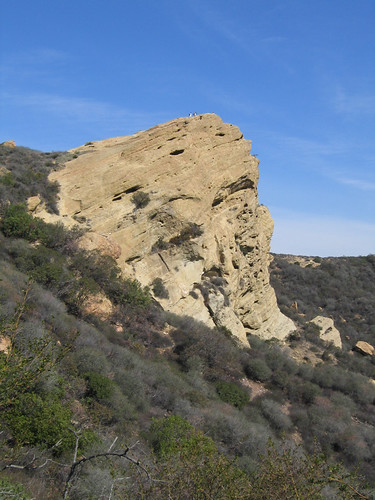
Eagle Rock
From the top, your view stretches south over the Palisades and out to the hazy Santa Monica Bay. Be sure to sit a while, enjoy the breeze and take in the view.

Looking south from Eagle Rock towards a hazy Santa Monica Bay
Returning to the trail, continue west and down to Eagle Junction. When you arrive, turn sharply right and take the signed Musch Trail heading back towards Trippet Ranch.

Looking East towards Trippet Ranch
For the next two miles you’ll finally be off of the fire roads and on true trail. The Musch Trail swings in and out of open grasslands and riparian areas in little ravines under oak and sycamore trees.
After a mile the Musch Trail enters a grove of eucalyptus trees and a small trail campground, used by horseback riders and hikers on the Backbone Trail. Passing through the campground, cross the road and continue another mile, finally arriving at the northeast corner of the parking lot and your starting point.
Total distance: 6.7 miles
Elevation Gain/Loss: 1,200’/1,200′
Website: http://www.parks.ca.gov/?page_id=629
Directions: From PCH (State Route 1), turn north on Topanga Canyon Blvd. After driving through the little town of Topanga, turn right on Entrada Road and follow the signs one mile to the park entrance at Trippet Ranch. From US 101, take Topanga Blvd. South, turning left at Entrada Road and follow the signs to the park entrance. Day use parking is $6.


gh: what camera do you use?
p.s. i like the photo looking south form eagle rock!
By: charlotte harris on November 2, 2007
at 5:05 am
charlotte – I use an old Canon Powershot S50. I’d love to get something new (better glass, ability to attach filters), but it does okay.
Really, that was my least favorite!
By: geekhiker on November 3, 2007
at 10:37 pm
Hi geekhiker,
My friend forwarded this site to me. I have to see Eagle Rock. The way you described the trails, I just want to leave work right now and head for the mountains.
So many trails, so little time….
By: Lucy on November 5, 2008
at 11:37 am
I know you did this hike quite some time ago, but I wanted to say thanks for leading the way! I went this past weekend with 8 others (I organize a hike each Sunday, so it’s gathered a good number).
I have to say, it killed us with the 7 miles on a hot day but we loved every minute of it!
By: Martina on March 4, 2009
at 4:29 pm
[…] References to this hike can be found on Hiking Eagle Rock and Temescal Peak | Modern Hiker and Hike: Eagle Rock Loop « The (Single) GeekHiker. Took me about 3 hours to do this hike with plenty of stops to dangle between rocks and take […]
By: Eagle Rock and Temescal Peak « Jojo Kahanding’s Blog on July 27, 2009
at 7:44 pm
[…] References to this hike can be found on Hiking Eagle Rock and Temescal Peak | Modern Hiker and Hike: Eagle Rock Loop « The (Single) GeekHiker. Took me about 3 hours to do this hike with plenty of stops to dangle between rocks and take […]
By: hubogsukat.com Blog » Blog Archive » Eagle Rock and Temescal Peak on July 28, 2009
at 1:12 pm
[…] More information: here; trip reports here. […]
By: Eagle Rock Loop in Topanga State Park « Nobody Hikes in L.A. on September 8, 2010
at 9:48 am
[…] Trippet Ranch to Santa Ynez Falls on geekhiker.com […]
By: Eagle Rock Trail | Los Angeles | Hikespeak.com on April 28, 2014
at 12:45 am