Growing up in Sacramento, I was constantly reminded of it’s history, specifically that of the Gold Rush and railroads.
Los Angeles is a town that has a tendency to constantly tear down it’s history in favor of building something new. Preservationists in this town have a devil of a time saving old, often quite beautiful structures from the wrecking ball.
While the structures on San Vicente Mountain are far from what one would define as beautiful (well, I suppose that all depends on your personal taste), the hike is a trip back in time to the Cold War and how Los Angeles prepared itself for imminent attacks at the time.
The trail to San Vicente Mountain Park can be reached by shorter means, but this hike takes the Caballero Canyon trail and fire roads to the top. Note the hike is sunny and exposed for most of it’s length, so avoid this one on a hot day. Best times are during the spring, fall, and winter, especially if winter winds have cleared the air allowing for best views.
From the trailhead across from the Country Club, proceed down the canyon, crossing the wash and following the (usually dry) stream bed. Watch out for mountain bikers on this trail. Although most are great and will call out their approach, blind corners can make for some close calls with even the nicest bikers.

After about a mile, the trail swings south and starts to ascent. A series of switchbacks (only a couple of steep ones) will lead you to the dirt portion of Mulholland Drive. Take a breather here and look south down Rustic and Tamescal Canyons towards the ocean beyond.

Turning left (east) follow the road as it winds along the ridge. To your north, views of the San Fernando valley and it’s grid of streets stretches out before you.

After about 2.2 miles of walking, you reach the entrance to LA96C.
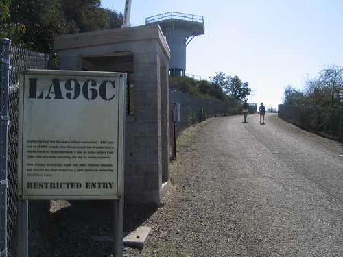
This was a Nike missile radar installation from 1956 through 1968, built for detection of incoming Russian bombers. The Nike missiles themselves were located in the Sepulveda Basin to the north of this location.

Take time to explore the ruins and read the informational signs. Climbing the metal stairs to the top of one of the old radar pads, you can get a panoramic view of the area surrounding you.

When you’ve had your fill of Cold War history, return by the same route.
Total Distance: 8.5 miles
Elevation Gain/Loss: 1,000′/1,000′
Website: http://www.lamountains.com/parks.asp?parkid=54
Directions: From Highway 101, exit at Reseda Blvd and turn south. Drive about 2 miles and park across the street from the entrance to the Braemar Country Club. The trailhead is on the left (south) side of the road.


i’ve sat on the top of the platform, and felt it sway in the breeze… need to do that again!
By: Piper on June 30, 2010
at 6:54 pm