(For some reason I ended up uploading a lot of pictures from the hike, so I’m not posting them all below. You can see them on the Flickr site here.)
Charmlee Wilderness Park, run by the City of Malibu Parks & Rec Department, is one of those little gems in the Santa Monicas that makes for a quiet, easy day.
It’s generally not too crowded, has a nice little nature center, a great picnic area under old oak trees, and hiking trails that can be hiked (well, more wandered really) by people of all ages and abilities. I’ve detailed a short 2.1 mile hike below, but the total trail mileage in the park is about 8 miles.
The hike and pictures below are from a couple of weeks ago. The park right now is green and starting to get its crop of spring wildflowers, which makes right now a great time to visit, but don’t let that stop you from traveling there any time of year.
After parking in one of the two dirt parking lots and paying the $3 entrance fee at the iron ranger, proceed past a couple of picnic tables along the road. From here, you’ll have a view over the canyon and out over the pacific beyond which, when I started, was covered in a layer of fog.

Looking out over an ocean of fog
The road will turn right at an informational signboard, where you’ll find placards about local wildlife and wildflowers and park maps. You can turn right here and follow the road a short distance up the hill to the nature center.

The Nature Center
Past the nature center, the road continues up the hill and around an old watertank, but our trail goes straight past the informational signboard and through the oak-shaded picnic area. We then angle uphill to a four-way trail junction near the top.

Heading up the shady trail past the picnic area
Ahead is a rocky outcropping and the remains of the old ranch house that stood here. To the right is the trail coming down from the tank hill. Turn left and proceed down into the grassy flats.

Just past the junction, heading down towards the meadow
Continue downhill and turn right at the first junction, heading through the meadow, covered in spring by green grasses and wildflowers.

The meadow


Some of the spring wildflowers (more on the Flickr site)
Crossing the flats you’ll arrive at the bluff, affording good views out over the ocean, spanning from Palos Verdes in the south to the Channel Islands in the north.
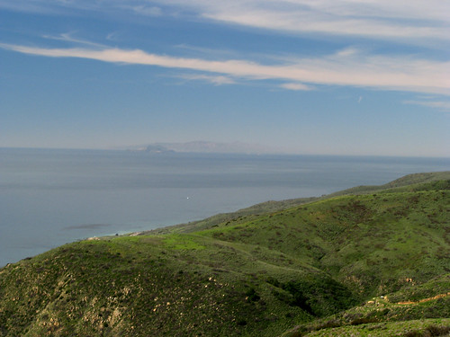
Looking out towards the Channel Islands
The trail to the right will take you to an oak glen, but we’ll turn left and go a bit more uphill to an old concrete reservoir. From here you can look down towards Point Dume and Zuma Beach.

Zuma Beach & Point Dume
Rounding the pond, angle left back towards the meadow, heading downhill. It was at this point I caught sight of a coyote, staring at me before disappearing off into the brush. I barely got of one shot before he was gone.

Coyote just before disappearing
Later in the afternoon while lazing about at my picnic spot he appeared again, wandering across the field.

Coyote wandering late in the day
What I love about this is that I saw hikers crossing the meadow all day, completely oblivious to him being in the brush nearby. Sometimes the wild is a bit closer than we think, and he went about his business without being disturbed.
Continuing along the trail, you’ll cross through a shady oak glen.

Oak glen along the trail
Past the oak glen, you can angle left and back up hill to the four way junction, or continue straight, which will take you back to the picnic area.
My suggestion: bring a good lunch, pick up a park map, and explore.
As a side note, part of this park burned in 2003. I was able to find and scan a few slides from a hike I did through the area a couple of months after the fires were out. For example, this is part of the oak glen in the photo above just after the fire:

More ’03 photos are on the Flickr site here as well.
Total Distance: 2.1 miles
Elevation Gain/Loss: 400′/400′
Website: http://www.ci.malibu.ca.us/index.cfm?fuseaction=DetailGroup&CID=3801&NavID=174
Directions: From Highway 1, turn north on Encinal Canyon Road and drive 3.8 miles to the park entrance on the left. From the 101, exit at S. Westlake Blvd (County Route 23) and drive 7.9 miles south (the road will turn into Decker Canyon Road), turn left onto Encinal Canyon Road and drive about 1.3 miles to the park entrance on the right (the roads are a bit of a maze in places, so if you’re coming from the 101, check your map first).


Informational signboard you say…
By: just a girl on March 28, 2008
at 5:53 am
Nice panoramics.
You’ve gotta GPS, right?
Ever thought of using it along with Google Earth to track your photos? For example, see this website: http://ourhikes.freespeech.com/
I think I’ll try giving it a shot the next time I’m out.
By: pneumoniaBoy on March 28, 2008
at 6:51 am
i love the flower pics… guess i’m jonesin’ for the real thing now that spring is here and they’re trying to poke through the dirt out here…
By: charlotte harris on March 28, 2008
at 11:32 am
Looks like you’ve been playing around with the Macro function of your new camera. Nice pictures, as usual.
We saw a coyote on the way to LAX on Tuesday. I’ve heard them on the trail but I’ve never had the pleasure of seeing one.
By: Homer-Dog on March 29, 2008
at 1:38 pm
Your weather, my goodness! You can probably seen my green all the way from there. We’re getting there, spring is on its way…
By: Backpackermomma on March 30, 2008
at 5:13 pm
just a girl – you would prefer “kiosk” perhaps?
charlotte – Thanks. Be sure to send pictures of the eastern flowers!
pneumoniaBoy – I’ve thought about it, but it would just be that much more work on a hike!
Homer-Dog – Would you believe I’ve had batter luck stepping back & zooming out? I’ve seen coyotes wandering along the roads in the Santa Monicas without a care in the world. Hopefully you’ll see one eventually.
Backpackermomma – 🙂 Hopefully spring will reach you soon!
By: geekhiker on March 30, 2008
at 6:13 pm
[…] Charmlee Wilderness Park on geekhiker.com […]
By: Charmlee Wilderness Park | Malibu | Hikespeak.com on April 28, 2014
at 10:17 am