In its day, the Mt. Lowe railway was one of the must-see attractions in Southern California. No vacation was complete with out it.
Starting from a trolley line in Altadena, passengers took an incline railway to lofty Echo Mountain, where they could stay at The Chalet or the Echo Mountain House. From Echo Mountain, they could board the electric Mt. Lowe Railway for the scenic trip up the mountain.
From Echo Mountain, the railway climbed another 1,300 feet in about three and a half miles, passing viewpoints with evocative names like the Cape of Good Hope and the Granite Gate. At the end passengers were delivered to Ye Alpine Tavern (later the Mt. Lowe Tavern), nestled in the forest on the slopes of Mt. Lowe, for respite a world away from the city.
Funded by balloonist Thaddeus S. C. Lowe starting in 1892, he would eventually be bankrupted by the venture. For most of its history the railway was run by the Pacific Electric Railway until, in 1936, the burning of the Tavern hastened the end of the operation.
Today, the old railbed between Echo Mountain and the Tavern location has been converted into a hiking trail. The Scenic Mt. Lowe Historical Committee has cleaned up the trail, added historical markers and information, and even rebuilt the scenic ramada at Inspiration Point, located a half mile east of the location of the old Tavern (which itself has been converted by the Forest Service in to a trail camp).
The trail described here will take you to Echo Mountain, then up the old rail route to the Tavern site and Inspiration point; a shorter trail returns to Inspiration Point and the route down. Much of the trail is exposed, and best avoided during the sweltering summer months.
* * *
From the trailhead, walk past the old stone gate and up the remnants of the road at the long-gone Cobb Estate. After about 150 yards, just as the road bends to the left, continue straight, taking the marked Sam Merrill trail. The trail briefly drops to the bottom of Las Flores Canyon, crosses the bottom across the top of a debris dam, and starts switchbacking up the east canyon wall. (Be sure not to take the Altadena Crest equestrian trail, which continues going down canyon.)

The entrance gate at the Cobb Estate

Ascending the Sam Merrill Trail, downtown LA and the Palos Verdes Peninsula in the distance

Photo of the Sam Merrill switchbacks taken on the return down during the sunniest part of the day
The trail, shady in the morning but quite exposed in the afternoon, gains altitude quickly, revealing an ever-expanding view of the Los Angeles basin. After 2.5 miles of continuous climbing you will arrive at the first trail junction. For the moment pass this, continuing straight past two more trail junctions (for the Sam Merrill Trail and Castle Canyon Trail) to arrive at Echo Mountain.
At Echo Mountain you’ll find the remnants of the old station: foundations of buildings, old hardware, etc. Behind you tower the mountains you’ll soon be climbing to Inspiration Point, before you stretches the broad LA Basin. On a clear day, downtown, the Palos Verdes Peninsula, Catalina and the Pacific are all clearly visible.
Panoramic view from Echo Mountain

Downtown LA from Echo Mountain

Remnants of the old buildings at Echo Mountain

Old hardware from the incline railway at Echo Mountain
After you’ve taken in the view, retrace your steps to the first trail junction, turning right. You’re now walking on the old electric railway right-of-way, crossing again Las Flores Canyon. The next three and a half miles continue ascending up the mountain, occasionally walking over ties still embedded in the soil. Every so often an informational signpost, usually with a historic picture of the same location, describes what was here all those years ago.

Information sign at Sentinel Rock

The same section of trail today
.8 miles after leaving Echo Mountain, you’ll arrive at a paved road. The trail (now a fire road) continues right, but be sure to take the brief detour around the large rock in front of you. Known then as the Cape of Good Hope, the original railway ran in a 200 degree arc around this point, then continued on the longest straight stretch of track on the trip: a mere 225 feet.
Shortly after the Cape, the trail enters mixed pine forest. Views of the city appear and disappear as the trail goes in and out behind mountain ridges. 3.5 miles after leaving Echo Mountain, you will arrive at Mt. Lowe Trail Camp, built on the remnants of the once-great Echo Mountain house.

Forested section of the old railway

The Granite Gate, where the railroad was blasted out of solid granite. Note the original support for the overhead wire that powered the cars
After you’ve finished exploring the camp (and, if you’re anything like me, reading all of the informational plaques), continue southeast along the fire road, passing the junction with the Sam Merrill trail. One-half mile after leaving the trail camp you will arrive at Inspiration Point.
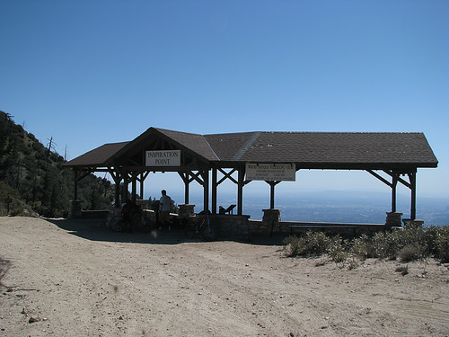
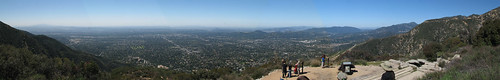
Inspiration Point

The panoramic view from Inspiration Point

Sighting tubes at inspiration point (I tried, but I couldn’t find the Ostrich Farm, sadly)

Looking down at Echo Mountain from Inspiration Point (the reverse of the view of the ruins above)
Just east of Inspiration Point take the signed Castle Canyon trail. The trail drops steeply down the wooded canyon for about two miles, returning you to Echo Mountain.

Looking up at the ramada at Inspiration Point from the Castle Canyon Trail
From there, retrace your steps down the Sam Merrill Trail to the Cobb Estate trailhead.
More photos here.
| Total Distance: 12 Miles
Elevation Gain/Loss: 2,800’/2,800′ Website: http://www.fs.fed.us/r5/angeles/ Directions: From I-210, in Pasadena, exit at Lake Ave. north. Drive 3.6 miles North on Lake Ave. to E Loma Alta Drive; the old stone entrance to the Cobb Estate is located where the two streets meet. Park along the street, being sure not to block private driveways. Hike Profile: |


That view of LA from Echo Mountain is amazing. What a lovely payoff!
Hey, is this one of those trails where they warn you to watch out for mountain lions? Have you ever had to run/jump/hide/fight a mountain lion?
By: Dingo on May 6, 2009
at 10:00 pm
Looks like a great hike. Great pictures, as usual. Wish I was there so I could do that trail.
By: Homer-Dog on May 7, 2009
at 6:26 am
I’m way too close to sea level to be able to handle it. Looks like LOADS of fun, but given my crazy legs, it would never work. Looks wicked fun though.
By: cripkitty on May 7, 2009
at 10:18 am
You easily can do this hike, living at sea level means nothing because this is not a high elevation hike! 🙂 Altitude will only start affecting people at more than 5,000 feet.
By: Candace on February 13, 2012
at 8:01 am
I’ve done this hike a bunch of times and never been to inspiration point! It’s so cool!
And I don’t want to hear anything about us not hanging out when you were practically in my backyard and you didn’t even call, Mr…
By: Mel Heth on May 7, 2009
at 10:38 am
Gorgeous pics… god, I want to live in Cali!
By: Little Miss Obsessive on May 7, 2009
at 12:31 pm
Gotta love these urban hikes. This looks like a really nice one.
By: Phil on May 7, 2009
at 1:08 pm
I love hikes with the addition of old stuff laying about…I had the best time camping/hiking in Joshua Tree last summer and seeing the remains from the mining days. This looks like a great hike.
By: sknielson on May 8, 2009
at 6:53 am
Dingo – I’m aware that mountain lions are out there but honestly? I have yet to see one. Of course, now that I’ve replied to your question, I’ve probably jinxed myself…
Homer-Dog – Missing those elevation gains, eh?
CripKitty – Actually, I live pretty close to sea level myself. I think you’d be okay on the old rail section, but the trip to Echo Mountain is a bit steep. 😦
Mel Heth – Time to go then. As I recall, you were gallivanting around France when I did this hike…
LittleMissObsessive – Do you? There’s an awful lot of neighbors to deal with…
Phil – It’s amazing how quickly one leaves the urban behind…
Sknielson – Welcome to the blog. It is always nice see some history along the trail…
By: geekhiker on May 10, 2009
at 8:19 pm
a little history while hiking is always a good thing. and i really like that giant wheel – so cool. and, of course, the views…
By: blakspring on May 11, 2009
at 12:05 pm
Very, very cool! I’ve never had the ooomph to get up to the top of this particular hike.
By: Peggy Archer on May 28, 2009
at 9:58 pm
Blakspring – It is a very well-rounded hike.
Peggy Archer – Tell you what, when your foot’s all better, we’ll go up together!
By: geekhiker on May 28, 2009
at 10:31 pm
Even better on a mountain bike! Wicked climb and the downhill is crazy fun!
By: Don1138 on August 2, 2009
at 7:39 pm
Can folks actually CAMP at the Mt Lowe trail camp? I was thinking of doing this as an overnight backpacking trip, thinking that the stars must be amazing.
By: PJ on July 3, 2012
at 8:47 am
[…] https://geekhiker.com/2009/05/06/hike-mt-lowe-railway/ […]
By: Mt. Lowe Railway | on November 3, 2012
at 10:28 pm
[…] lot about all the parks I’ve written about and encouraged my readers to go to, whether in the Angeles National Forest, or the Santa Monica […]
By: A Walk In The Park « The (Single) GeekHiker on December 7, 2012
at 8:27 am
[…] I hiked up Mt. Lowe and had a Fantastic time! It is so spectacularly beautiful up there, and wow, what a hike! It’s a terrific […]
By: Marvelous Mt. Lowe | Totally Traci on November 19, 2013
at 7:15 pm
[…] Sam Merrill Trail to Echo Mountain on Inspiration Point on geekhiker.com […]
By: inspiration Point & Mount Lowe Trail Camp | Los Angeles | Hikespeak.com on November 28, 2013
at 9:03 am
[…] information: Trip descriptions here and here; Yelp page here; Meetup description here; Wikipedia article about the history of the Mt. […]
By: Mt. Lowe Railway Loop | Nobody Hikes in LA on December 25, 2014
at 8:08 am
[…] in 2010 I trained on Sam Merrill because it was the final stretch of the Angeles Crest 100-miler. I figured I ought to be […]
By: Walk Across America – Training Day #1 | tom griffen on June 29, 2017
at 10:58 am